Thursday, October 29, 2009

Maine Mineral Photo of the Day


Pink tourmaline and purple lepidolite in cleavelandite, Greenlaw Quarry, Mount Apatite, Auburn, Maine.

Saturday, October 24, 2009

Maine Mineral Photo of the Day


This is a uraninite crystal from the Swamp #1 Quarry, Topsham, Maine collected in 1996. It is about the size of a pea with a chevron face and the high gloss surface typical of the Swamp #1 Quarry specimens.

The Swamp # 1 Quarry is a very small early 1900s feldspar mine which has produced some of the finest uraninite crystals in the world. I found this by waving a Geiger counter over the various pieces of quartz/feldspar dump rock until it squawked. Upon breaking up the chunk of feldspar with a sledge, this little bugger popped out. Uraninite is uranium oxide (UO2). In most of the Topsham granite pegmatite quarries the uraninite is at a higher oxidation level (UO6 or UO8) which causes the crystals to lose their sharp crystal faces and edges and become small, black, chalky blobs, ie. pitchblende, often mixed with a wide range of colorful alteration minerals such as autunite, torbernite, uranophane and others.

The uraninite locality at the Swamp #1 Quarry was discovered in 1958 by Clifford Trebilcock, Jr. of Topsham when he was 13 years old. The quarry was subsequently drained of water and his parents joined him in recovering a large number of high quality uraninite crystal groups. For many years Trebilcock stubbornly refused to say where in Topsham he was finding these uraninite crystals. Because the Topsham pegmatite district has hundreds of large and small quarry pits stretched out over a dozen square miles, competing collectors were stymied in locating where Trebilcock was making his finds. Only with the publication of Maine Mineralogy, Vol. 1 in 1994 did Trebilcock finally reveal that the Swamp #1 Quarry was his source.

Click here to embiggen.

Here's a nice photo of one of Trebilcock's early finds.

Friday, October 23, 2009

Kennebec Indian Post of the Day: A Plummet


This is a plummet. It was found by Tim Watts at Babcocks Rapids on the Kennebec River in Augusta, Maine in 2000 where we have found many prehistoric stone tools along the river bank, and also prehistoric sturgeon bones. Many purposes have been proposed for plummets, including a fishing sinker or a weight for a net, but nobody really knows what they were used for.

Plummets of many sizes were common during one period of civilization in Maine, the "Red Paint People" period, 4,500-3,700 years ago, but are rarely found before or after that period. They were made by pecking the stone with a harder stone.

They took a lot of time and skill to make. Getting that nice, tight smooth collar must have been a task.

I do not believe plummets were made or used as fishing or net sinkers. They took far too long to make and are too carefully made for such a throwaway purpose. Anyone who has fished knows that fishing sinkers of the shape represented by plummets are lost very quickly by getting jammed into crevices in the bottom or wrapped around sunken logs, causing the loss of all your line and gear. For the same reason, the use of large plummets as net weights is equally doubtful. These items took days to weeks to make, and if used as net weights would be extremely susceptible to loss by entanglement in bottom clutter. There is no evidence that 4,000 year old Native Americans ever used large nets to catch fish; and if they did it would be much easier to stitch or tie appropriately sized and shaped pieces of unworked river rock into the lowest part of the net to act as disposable bottom weights. What we know of fishing techniques from Contact Period Native American culture is that very large fish, like sturgeon, were caught by spearing and harpooning, and smaller fish like alewives were caught in their spawning streams using stone and brush weirs.

Given these facts, and the unique appearance of plummets during the "Red Paint" culture of New England Indians and their disappearance thereafter, I believe plummets were made as ceremonial objects. Their similarity to a male testicle may not be coincidental.

This plummet is about 4,000 years old.


Tim Watts at Babcocks Rapids, Kennebec River, Augusta, Maine. The place where he found the plummet is at the boulder point. This is where 6 foot long Atlantic sturgeon congregate in the summer to jump and spawn.

Tim found this plummet because in 1999 the Edwards Dam was removed from the Kennebec River, two miles below. You can see the "bath tub ring" of the dam's impoundment at the tree line along the opposite bank of the river. Removing this dam took 15 years of fierce legal fighting by concerned citizens of the area, which was the most recent in a 150-year effort to remove the dam by many local people now dead and forgotten.


UPDATE: Bob Doyle, retired State Geologist of the State of Maine, has examined this plummet as to its lithic type. His conclusion is that it is a metamorphosed siltstone.

Wednesday, October 21, 2009

Prehistoric Kennebec River channel


This summer I found this old, prehistoric channel of the Kennebec River about 1/4 mile from the river at Five Mile Island in Vassalboro, Maine. I believe that this old channel is still a meadow because when the Edwards Dam impoundment was in place from 1837-1999) spring flood flows would overtop the bank and fill the channel once or twice a year.


View Larger Map

The old channel is the light, non-wooded vertical patch in the upper center of this aerial photo on the right side of the river. Below is a terrain map.


View Larger Map

Below is a closer look at the old channel, which is now a meadow with scattered trees. The entire area is criss-crossed with beaver paths.


View Larger Map

View Larger Map
The prehistoric channel at Five Mile Island, prior to be cutting off, probably resembled this existing side channel on the Kennebec River in Sidney, about six miles upstream. This aerial photo was taken at very high flows and shows a side channel separated by a "teardrop" shaped gravel bar island from the main channel. This area was completed filled with silt and debris from the impounding effect of the Edwards Dam and is only now starting to regain its natural channel configuration, as spring floods remove the 160 years of in-filling from the dam's construction in 1837.

View Larger Map
A mile farther upriver, on the Vassalboro side, is another set of prehistoric side channels, which are now wooded swamps separated from the river by the railroad grade which cuts through them.

Tuesday, October 20, 2009

Maine Mineral Photo of the Day


Albite crystal group (var. Cleavelandite), Fisher Topaz Pocket, Fisher Quarry, Topsham Maine, 1996.

Rockabameecook, Canton Point, Androscoggin River, Maine


The broad alluvial plains along the Androscoggin River at Canton Point, Maine is called Rockabameecook by American Indians. It is a very old corn planting place. It is still used for planting corn and potatoes today.

This was filmed in a potato field along Route 108 in Canton last fall. The reason I filmed this was because there was one lonely, defiant corn plant in this giant potato field. I am assuming they had planted this part of the field in corn the year before and this corn plant self-seeded. It looked so noble and kool standing all by itself that I had to make a movie about it.

And then there's the song about Route 108.

Hockomock Swamp video


This is a movie I made in July, 2009 of our little trek into one of the most remote parts of the Hockomock Swamp in South Easton, Massachusetts to a grove of old growth Atlantic white cedar. The video doesn't play well on my computer unless you let it load completely before playing, which takes a few minutes. It looks about a gajillion times better on DVD. If you want a copy send me a note at info "at"dougwatts.com

The weird red-lit stuff at the beginning with the sunshine was done by putting the video camera underwater in Black Brook and pointing it up at the sky. You can see how red the water is, which is due to tannin leaching from the leaves in the swamp.

I made this video primarily to document the size of the Atlantic white cedars in this part of the swamp, but due to Queequeg T. Dog, Ph.D.'s enthusiasm, it came out the way it is. It is presented with the intent of encouraging other folks to take their own little trek into the Hockomock and to encourage its permanent preservation and protection.

Assawompsett Indian Post of the Day


Jasper arrow head from White Banks, Assawompsett Pond, Middleborough, Massachusetts. Found by Doug and Tim Watts, 2003. 10 minutes later at this same spot we saw a hog nosed snake in the sand and it puffed up at us. Yellow bar is 1 cm.

Monday, October 19, 2009

Maine Mineral Photo of the Day


Glass quartz with radioactive burns from dump next to Square Pit, Fisher Road, Topsham, Maine. 1992.

Saturday, October 17, 2009

New Evidence Doubles Historic Range of Striped Bass in the Kennebec and Penobscot Rivers, Maine


Striped Bass, Plum Island, Newbury, Massachusetts.

By Douglas Watts
Augusta, Maine
October, 2009

New historic and archaeological evidence shows striped bass migrated much farther up Maine's Kennebec and Penobscot Rivers than previously imagined.

Up until 2000, the "conventional wisdom" of Maine fisheries biologists was that striped bass did not migrate up the Kennebec River past Waterville and Winslow, Maine (20 miles above the head of tide) and did not migrate up the Penobscot River past Indian Island at Old Town (10 miles above the head of tide).

Matt Kay of Augusta, Maine with a striped bass on the Kennebec River in Augusta, Sept. 1996. The Edwards Dam can be seen in the background. It was removed three years later.

Striped Bass from Kennebec River at Pettys Rips, Waterville, Maine, 2004, 15 miles above the site of the Edwards Dam, removed four years earlier. The striper was electrofished and released as part of a biological study (Yoder et al. 2004).

Kennebec and Sebasticook River Striped Bass

The "conventional wisdom" on the Kennebec River was overthrown in 2002 with the discovery of burned, calcined striped bass bones at a 1,000 year old Ceramic Period prehistoric habitation site on the East Branch Sebasticook River in downtown Newport, Maine (Spiess 2003). The striped bass bones were found 50 miles upstream of the confluence of the Sebasticook and Kennebec Rivers at Waterville and Winslow, Maine. This archaeological find shows that prior to 19th century dam building, striped bass seasonally migrated into and inhabited most, if not all, of the Sebasticook River watershed, and were sought and captured as food by the native people who lived in the area 3,000 years ago.

Site of 1,000 year old fishing and habitation site at outlet of Sebasticook Lake, Newport, Maine on East Branch Sebasticook River, May 2004.

Prior to this discovery, the migration limit of striped bass in the Kennebec River was assumed to be near the confluence of the Kennebec and Sebasticook Rivers in Winslow, Maine, based upon historic evidence in Atkins (1869) which stated that prior to dam building, the migration of striped bass was stopped at Ticonic Falls on the Kennebec River in Waterville and striped bass only migrated "a short distance" up the Sebasticook River above its mouth.

Red arrow at Waterville shows previously assumed upstream limit of striped bass in Kennebec River. Red arrow at Sebasticook Lake in Newport shows additional migration area based on striper bones found in 2002 at Ceramic Period habitation site at outlet of Sebasticook Lake.

The earliest version of Charles Atkins' Fishery Commissioner Reports to the Maine Legislature (Atkins 1867) states that, prior to damming, striped bass went "some distance" up the Sebasticook River. It is not known why Atkins in 1869 changed the language of his 1867 report ("some distance" up the Sebasticook) to the more narrow and conservative phrase, "a short distance" up the Sebasticook.

Charles Atkins' first Maine Fish Commissioners Report in 1867 regarding striped bass shows he got it right in his first report and got it wrong in his later reports. Atkins' reference to winter fishing in the Eastern River in Dresden, Maine (an estuarine tributary of the lower Kennebec River) gives a rather strong clue as to why striped bass had become extremely scarce by the time of his writing. These folks in Dresden were wiping out the entire population of native, sexually mature striped bass overwintering beneath the ice in the lower Kennebec River. Once they caught them all, there were none left to spawn the next spring. Oops.

The construction of the Edwards Dam on the Kennebec River at its head of tide in Augusta, Maine in 1837 ended all migrations of striped bass, Atlantic salmon, American shad, alewives and other fish species up the Kennebec River. For this reason, Charles Atkins was forced to rely upon interviews and recollections of elderly people in the Kennebec River valley to reconstruct the geographic range and migrational extent of striped bass and other fish in the Kennebec River. Atkins himself had never seen the Kennebec River in its natural, undammed character.

Tim Watts with a large striped bass from the Kennebec River at Hallowell, Maine, June 1997. This is a joke photo since we saw the striper floating dead on the river and I convinced Tim to hold it up as if he had caught it.

The archaeological evidence gathered by Spiess (2003) doubles the known, historic migrational range of striped bass in the Kennebec River system, from approx. 50 miles above saltwater to more than 100 miles above saltwater. This discovery also calls into question many of the "conventional wisdoms" held by fisheries biologists regarding the extent to which striped bass utilized freshwater habitat in large coastal river systems. One of these conventional wisdoms is that striped bass tend to confine themselves to the large, deep portions of rivers near and below the head of tide even in the absence of natural migration barriers.

Blue line shows previously assumed historic range of striped bass in Kennebec River system. Red line shows additional range based on archaeological evidence from Sebasticook Lake in Newport.

The Penobscot River Striped Bass

An eyewitness account from 1825 describes very large striped bass in the Piscataquis River, 20 miles above Old Town. This account is taken from early 19th century Bangor newspaper articles summarized in Godfrey (1882). The articles describe a massive forest fire in August of 1825 that burned the lower Piscataquis River valley and the Penobscot River valley from Mattanawcook to Passadumkeag. It states:

"1825: For a fortnight fires were raging in the forests north of Bangor. At one time nearly the whole country from Passadumkeag to Mattanawcook, on both sides of the Penobscot and Piscataquis, was a sea of flame. The roaring of the fire was like thunder, and was heard at a distance from twelve to fifteen miles. The islands in the river were burnt over. The country between Passadumkeag and Lincoln was devastated. The towns upon the Piscataquis suffered from loss of buildings, cattle, fences, crops. The house, barn filled with hay, and store and toolhouse of Joseph McIntosh, of Maxfield, were burned and the family driven to the river for safety. Other houses and barns, and saw-mills and grist-mills, were destroyed. A lad returning from school through the woods was so badly burned that his life was despaired of; hawks and other birds were killed by the fire; and the fish in the Piscataquis River were killed by the heat. Twenty bass, weighing from twenty to forty pounds, many young salmon, shad, trout, and other small fish, were found dead in the shoal water and on the shores."

Red arrow at Old Town shows previously assumed upstream migration limit of striped bass in Penobscot River system. Red arrow in upper left shows the area of the intense forest fire in 1825 in which large striped bass were found dead in the Piscataquis River.

Eyewitness documentation of very large striped bass in the Piscataquis River in 1825 has profound significance for our understanding of the natural ecology of the Penobscot River marine-riverine ecosystem. The gentle gradient and lack of any steep falls on the mainstem Penobscot above Indian Island means striped bass had access to the entire Penobscot River mainstem, the lower reaches of the East and West Branches of the Penobscot in Medway and East Millinocket, and the Piscataquis, Passadumkeag and Mattawamkeag watersheds below their first major falls. All of these waters supported large alewife, blueback herring and shad populations which would give the striped bass an incentive to follow the runs upriver in spring and remain to feed on spawned out adults and down-migrating juveniles in the midsummer, late summer and fall. The name "Shad Pond" given to the lower West Branch Penobscot in Medway shows that the lower West Branch would have attracted feeding stripers during the entire summer and fall. The very large historic American eel population throughout the entire Penobscot drainage would give yet another incentive for striped bass to remain in the middle and upper Penobscot mainstem for significant portions of the year.

Blue line shows previously assumed historic range of striped bass in Penobscot River, based on belief that striped bass were blocked by rapids in Old Town. Red line shows historic range based on 1825 documentation of striped bass in the Piscataquis River, 20 miles above Old Town.

Danny Watts with a striped bass from the Weweantic River, Buzzards Bay, Cape Cod, 2007. This striper is of the size documented in 1825 on the Piscataquis River (20-40 lbs.). Stripers of this size are sexually mature females.
The size of the dead striped bass observed in the Piscataquis River in 1825 (up to 40 lbs.) shows the species was the apex predator and largest fish to inhabit the Penobscot River above Indian Island in Old Town.

The Two Imperatives of Striped Bass in Freshwater

Striped bass have two motivations to migrate up large coastal rivers into freshwater riverine habitat: feeding and spawning. Feeding forays into freshwater are spurred by the seasonal migrations of alosids (alewives, blueback herring and American shad) and American eel, all of which cohabit these waters with striped bass and prior to 19th dam-building, existed in very large numbers in the Kennebec and Penobscot river systems. Spawning is the second motivation. Striped bass spawn in freshwater and must deposit their eggs well above the freshwater/saltwater interface for them to survive. This is because striped bass are "broadcast spawners" and deposit their eggs in mid-river in June and early July. The eggs have neutral buoyancy and drift downstream with the current for 24 hours or more before they hatch. If the eggs drift into saline water (in excess of 1 ppt) before they hatch, they die. For this reason, sexually mature striped bass must migrate a considerable distance above the freshwater/saltwater interface in order to spawn successfully. Scientific papers supporting the above are as follows:

Atlantic States Marine Fisheries Commission (1995) states: "Historically, striped bass probably spawned in all larger rivers along the Atlantic Coast prior to the construction of dams and deterioration of water quality (ASMFC 1990). For many stocks, spawning areas are fresh to brackish waters and are generally located in the first 25 miles of freshwater in the river, with salinities of 0-5 parts per thousand. Some fish, such as those in the Hudson, Rappahannock, Roanoke and Neuse Rivers, migrate over a hundred miles upstream from the river mouths to spawn (Janicki et al. 1985)."

Dadswell (1996) states: "Striped bass are large, percoid fish which can attain lengths of 150 cm and weights of 40-50 kg (Scott and Scott 1988). Spawning is estuarine and freshwater usually near the head of tide in water of less than 1 part per thousand salinity (ppt; Setzler-Hamilton et al. 1981), but in some rivers as far as 120 miles upstream of tidewater (Roanoke River, N.C.; Rulifson and Mannoch 1990)."

Squiers (1988) states: "The spawning areas [of striped bass] range from head of tide in Chesapeake Bay to small tidal river systems 12 miles upstream to 80 miles above tidewater on the Roanoke River in North Carolina and 200 miles above tidewater on the St. John River in Canada. The location of spawning is probably an adaptation of certain stocks to the water temperatures at the time of spawning. Upriver spawners are probably early run fish while tidal river spawners would probably be late run spawners in order for egg incubation to coincide with availability of freshwater flow. This would allow for adequate incubation time before the fry reach low salinity waters. Studies by Rathjen and Miller (1955) demonstrated that live striped bass eggs in the Hudson River were not found in areas of salinity in excess of 1: 1,000. Therefore, upriver and near head-of-tide stocks of striped bass have to be very temperature sensitive in order to accommodate egg incubation time with extent of freshwater flow."

Scott and Crossman (1973) noted the presence of spawning striped bass in the St. Lawrence River as far upstream as Montreal: "Throughout its range the striped bass spawns in fresh water. In the St. Lawrence River there is a fall migration upriver, the potential spawners spend the winter in the river, then swim up to their spawning grounds in the spring, usually spawning in June. Prespawning fish may travel long distances upriver, in fresh water. In former years some large fish have been taken as far inland as lac Saint-Pierre and a very few individuals have been caught at lac Saint-Louis in Montreal ... In some rivers spawning occurs just above the head of tide, but in most cases the ripe fish seem to move well into fresh water before spawning."

The above citations clearly show that striped bass in many river systems select spawning habitat many miles above the head of tide; and that this adaptive behavior ensures spawning success by preventing striped bass eggs from reaching saline waters prior to hatching. The mainstem Penobscot River above Old Town is situated well within the range of spawning migrations observed for striped bass in large rivers in the eastern United States. The 1825 account describing large stripers in the Piscataquis River forces us to re-examine the conventional wisdom that the Penobscot River did not support a spawning population of striped bass. This account shows that striped bass of spawning size migrated 40-60 miles above the summer salt wedge on the Penobscot River. This is the same distance above saltwater influence that striped bass now travel on the Kennebec River (Bath to Waterville, approx. 60 miles) . Just like at the Kennebec River at Waterville, the mainstem of the Penobscot below Medway, Mattawamkeag and Howland is more than sufficient to allow striped bass eggs to incubate and hatch before reaching saline waters in the lower Penobscot River.


Are Striped Bass "weak" swimmers?

A common "conventional wisdom" against extensive freshwater migration by striped bass in Maine rivers is that they cannot negotiate large, steep ledge drops and falls on rivers, and for this reason were stopped by the first significant falls on a coastal river. This failure is variously attributed to striped bass being "weak" swimmers that cannot swim through heavy water and the inability of striped bass to leap clear out of the water, like Atlantic salmon, to pass over a falls. While it is true that striped bass do not leap straight out of the water like Atlantic salmon at falls, it is completely untrue that they are "weak" swimmers and cannot swim in currents easily negotiated by alewives, blueback herring and American shad. This is demonstrated by striped bass at the large tidal rips at Woods Hole, Cape Cod, Massachusetts.


Striped bass caught by Tim Watts off Nauset Light, Woods Hole, Cape Cod.

The Woods Hole Tidal Rips

Woods Hole gets its name by being a "hole" in the Elizabeth Islands, which separate Buzzards Bay from Vineyard Sound on the south side of Cape Cod. Because several hours separate the timing of high tide between Buzzards Bay and Vineyard Sound, twice a day an enormous tidal rip occurs in Woods Hole as water flows from Buzzards Bay (when it is at high tide) to Vineyard Sound (when it is below high tide) and vice versa. Because Woods Hole is shallow, these tidal rips create very strong currents and large standing waves (similar to Class IV whitewater) where the current breaks over submarine boulder piles and ridges. Large striped bass use these "rips" as feeding stations for bait fish swept through the channel at Woods Hole and can be caught in large numbers, even though the current is so swift that maintaining a boat in them is dangerous.

Kayaker and writer Dave Jacques describes kayaking the Woods Hole tidal rips in a 2005 article in Wavelength magazine:


"Woods Hole, like nearby Robinsons and Quicks Holes, is a narrow gap in the Elizabeth Islands through which tides pour daily, year in, year out. The tides run in concert with the phases of the moon and are so consistent that their patterns can be accurately detailed for years to come ... We paddle out into the Woods Hole channel with a hard lean and strong ruddering, and the kayaks slide into the heavy, 5-knot current. Surfing the standing waves produced by the current, we ferry out into the middle of Woods Hole. We look down and see the current is ripping along under us over rocky shoals covered with colorful seaweed and kelp. A striped bass shoots by. Rather than being swept backward by the current, however, we find ourselves surfing forward. We are riding the standing waves, letting them do the work."

U.S. Coast Guard charts show maximum tidal flow in Woods Hole Passage is about five knots. This is a current velocity of 8.4 feet per second. We know by direct evidence that large striped bass are extremely numerous in the rips at Woods Hole feeding during maximum tidal flow, which means they are inhabiting an area with a steady current of 8 feet per second. While stripers take advantage of velocity refugia behind boulders in this area, they frequently go straight into the main current itself to chase bait fish being blown through the passage. This figure of 8 feet per second is considered by U.S. Fish & Wildlife Service to be the maximum current velocity for upstream migrating fish (USFWS 2009).

Striped bass in the rips at Woods Hole passage are not trying to move through this heavy current to get upstream, but are selecting and sitting in these currents, day in and day out, eating smaller fish. This shows that rapids and tidal bores with a current velocity of 8 feet per second are often a preferred living habitat for large striped bass, not a "difficult spot" they would prefer to avoid, but must somehow pass through, in order to get upriver. It is hard to imagine how, among sea-run fish, striped bass could ever be called "weak" swimmers since of all sea-run fish, striped bass are the only ones which seek out and inhabit areas of extreme current for feeding and living purposes. Yet the "conventional wisdom" decrees this.

Yearling (9 inch long) native striped bass. Caught by Doug Watts at Negwamkeag, Kennebec River, Sidney, Maine in July, 2000, one year after the Edwards Dam was removed in Augusta in 1999. Negwamkeag is a Kennebec/Abenaki word which refers to large gravel bar islands.

The Problem with "Conventional Wisdoms"

The problem with "conventional wisdoms" in the natural sciences, in this case fisheries science, is they are often based on a lack of evidence and for this reason, are often profoundly wrong. On the Kennebec, modern fisheries biologists have relied exclusively on Charles Atkins' brief, anecdotal statements from the 1860s about the upstream migration limit of striped bass in the Kennebec River system. Because the Kennebec had been impassable to fish above its head of tide in Augusta since 1837, Atkins was forced in 1867 to rely solely on the recollections of "old timers" to gain any information on how far striped bass actually went up the Kennebec and Sebasticook Rivers before they were dammed. Newly acquired direct evidence, in the form of striped bass bones found on the Sebasticook River 50 miles above Winslow, Maine shows Charles Atkins' estimates of striped bass range in the Kennebec were wrong. We now know the range of striped bass in the Kennebec River system is twice as large as Atkins had estimated.

On the Penobscot River, Atkins said little about striped bass. Lacking any historic evidence, modern fisheries biologists themselves erected an arbitrary migration limit on striped bass at the rapids and ledges at Indian Island in Old Town. At this writing, the State of Maine Dept. of Marine Resources is uncertain if it will "allow" native striped bass to move up the Penobscot River past the Milford Dam in Old Town once access is made available with the pending removal of the two mainstem dams below it. This is based on the "conventional wisdom" that striped bass never swam past the Milford Dam site, in spite of direct historical evidence from 1825 which shows they did.

Danny Watts of North Easton, Mass. with a striped bass from the Kennebec River at Bacons Rips, five miles above Augusta, Maine. July, 2003.

David Watts of North Easton, Mass. (Danny's great uncle) and a friend with two striped bass caught on Cape Cod in the 1950s.

References Cited:

Atkins, C. 1867. Maine Fish Commissioners Report in Twelfth Annual Report of the Secretary of the Maine Board of Agriculture. Stevens & Sayward. Augusta, Maine.

Atkins, C. 1869. Report of the Maine Commissioners of Fisheries. Augusta, Maine.

Atlantic States Marine Fisheries Commission. 1995. Amendment No. 5 to the Interstate Fishery Management Plan for Atlantic Striped Bass. Fisheries Management Report No. 24 to the Atlantic States Marine Fisheries Commission. Washington, D.C.

Baxter, James P., editor. 1910. Documentary History of the State of Maine Containing the Baxter Manuscripts. Vols. 1-24. Maine Historical Society. Lefavor-Tower Company. Portland, Maine.

Buck, Rufus. History of the Settlement of Bucksport: 1763 to 1860. Unpublished, handwritten manuscript in Maine historical documents collection at Maine State Library, Augusta, Maine. Rufus Buck born in 1797, died in 1879. Manuscript written in 1860s era.

Dadswell, M.J. 1996. The Removal of Edwards Dam, Kennebec River, Maine. Its Effect on the Restoration of Anadromous Fishes. Prepared for the Kennebec Coalition. Augusta, Maine. March, 1996.

Godfrey, J.E. 1882. The Annals of Bangor, 1769-1882, in History of Penobscot County, Maine. Williams, Chase & Co. Cleveland, Ohio.

Jacques, D. 2005. "Playing in Woods Hole." Wavelength magazine. Gabriola Island, British Columbia, Canada. (pdf here).

Maine Dept. of Marine Resources. 2008. Strategic Restoration Plan for the Penobscot River. Maine Department of Marine Resources. Augusta, Maine.

Scott, W.B., E.J. Crossman. 1973. Freshwater Fishes of Canada. Bulletin 184. Fisheries Research Board of Canada. Ottawa, Canada.

Spiess, A. 2003. Newport Stream Restoration Archaeology Survey and Site 71.30. Maine Historical Preservation Commission. Augusta, Maine. (pdf here.)

Squiers, T. 1988. Anadromous Fisheries in the Kennebec River Estuary. Maine Department of Marine Resources. Augusta, Maine.

U.S. Fish & Wildlife Service. 2009. Letter of Andrew Raddant, Regional Environmental Officer, to Federal Energy Regulatory Commission on Application of Surrender for Great Works, Veazie and Howland Dam, Penobscot and Piscataquis Rivers, Sept. 2, 2009. USFWS, Boston, Mass.

Watts, D. 2003. Native and Commercial Fisheries of the Penobscot River. Prepared for the Penobscot River Restoration Trust. Augusta, Maine.

Yoder, C., J. Audet, B. Kulik. 2004. Maine Rivers Fish Assemblage Assessment: Interim Report. Midwest Biodiversity Institute. Columbus, Ohio.


Allan E. Watts of North Easton, Mass. night fishing for striped bass in the salt marshes of Haskell's Island, Aucoot Cove, Buzzards Bay, Mattapoisett, Mass. July, 1993.

Friday, October 16, 2009

Maine Mineral Photo of the Day


Gem tourmaline crystals. Greenlaw Quarry, Mount Apatite, Auburn, Maine. Found 1996-1997.

Assawompsett Indian Post of the Day


Quartz arrowhead, Titicut, Raynham, Mass. at Pratts' Bridge. Found by Doug Watts, 2004. Yellow bar is 1 cm.

Thursday, October 15, 2009

Maine Mineral Photo of the Day


Smoky Quartz crystal from an extremely radioactive and deadly section of the Wm. Willes #1 Quarry in Topsham, Maine, July 2000.

This quarry was dug in the late 1800s to extract high grade feldspar from the core of a granite pegmatite. The feldspar was ground up and shipped to pottery factories in New Jersey where it was used to make ceramic glazes.

Recent research shows that Topsham, Maine is the root of an exotic chunk of continental crust that slammed into the rest of North America about 350 million years ago.

Jasper Gouge, Sebasticook River, Winslow, Maine.


This rock doesn't look like much else than a rock.

Turned this way, it looks a little more suspect, but not too much.

But held properly in the hand, it is a perfectly fit hand gouge.

From the bottom and side, a crafted, curved blade surface becomes apparent.


This artifact has a funny story. Last Sunday, my brother Tim and I were looking over a Ceramic Period habitation and possible pottery kiln site on the lower Sebasticook River in Winslow, Maine. I found the rock above on the ground, in an area with numerous worked flint flakes, and because it was jasper with bright red flecks (which is uncommon on the Sebasticook), I pocketed it for our rock garden.

Later that Sunday night, I absentmindedly picked up the rock while we were all playing a board game and noticed how perfectly it fit into my hand, and when held in this position an even, curved cutting surface was apparent at the end of the stone, much like a small hand plane for woodworking. I then did a Homer Simpson, "D'Oh !!!!" and realized I had found a prehistoric hand gouge and didn't even know it.

Now, having examined it more carefully, I am convinced it is a hand gouge and was specifically made for this use. What convinced me is not just the shape and its tailor-made fit for the hand, is that it is made out of jasper.

Among Maine geologists, red jasper is a generic term for an extremely hard, tough and dense rock that appears in highly polished cobbles in the bed of the Kennebec River and Androscoggin Rivers and their headwater tributaries. A key diagnostic for this jasper is the presence of deep maroon to blood red swirls and specks within a larger matrix of black, gray and tan.

Robert Doyle (2008) describes the Kennebec jasper variety as a "cryptocrystalline variety of chert, lacking any kind of internal structure. Color is dependent on the content and chemistry of included iron oxide impurities. Red jasper usually forms in association with iron ores, such as those from the Minnesota Iron Range, and occasionally as exhalative deposits of basalt flows ... No local outcrop source for this lithology has been identified. The boulders in the glacial drift are well rounded, suggesting a lengthy journey from the outcrop source. The jasper boulders at New Sharon (Maine) are dark blood red to rusty-red colored, containing black and gray swirling mottles and fracture fillings of dark quartz. Red jasper is very dense, extremely durable and hard."

Close-up of swirling texture in a large jasper cobble from a marine clay deposit along the Kennebec River in Augusta, Maine.

One reason this type of jasper is an uncommon prehistoric tool material is that it is extremely hard and difficult to work, even for skilled prehistoric blade and tool makers. Because it is only found in polished, highly waterworn cobbles, any piece of jasper that has angular, non-rounded edges strongly suggests somebody was actively working it.

Red jasper cobbles from the Kennebec River, Augusta, Maine. These are about the size of golf balls. Dipping the cobbles in water brings out their intense red coloration, which is why I found all these in the shallow parts of the Kennebec River.

A key diagnostic of our Sebasticook River piece of jasper is that about 80 percent of the piece is broken, with just a few remnants of the original, water worn surface of the cobble still showing. Despite this, the angular, worked faces of the jasper are subtle and could be easily mistaken for a river stone cracked and broken by frost action along zones of weakness or structural bedding.

This illustrates the importance of identifying the lithic materials used by prehistoric tool makers and understanding their geological origin and textural character. Because I know from experience that this type of red jasper is almost never found except in very smooth, water worn cobbles, finding a highly angular chunk of this stone is a strong suggestion that it was worked, even if the form is not complete. In contrast, one can be easily fooled by an apparently "worked" surface on bedded rocks like schist or slate when what you are really seeing is the rock naturally splitting along bedding planes from frost or water action. Most of central Maine is underlain by tightly bedded and folded slate and schist, which creates countless thousands of "artifact-looking" rocks that aren't. Even more confusing is that the dominant bedrock in central Maine is a gray phyllite slate, which in small pieces looks almost identical to the dominant prehistoric flint type, the Mt. Kineo-Traveler Mountain rhyolite.

Wetting the jasper gouge shows the diagnostic blood red specks and tendrils. This stone has much more quartz and is coarser than most red jasper cobbles in the Kennebec River valley, which undoubtedly made it easier to make into a gouge. Arrow points to the carefully worked cutting edge.


The area below the yellow arrows has been struck off from the original jasper cobble. The red arrows show two separate strikes to create the inclined plane of the gouge and a hand-holding surface.


The cutting edge of the gouge, viewed from the bottom. All of the surfaces have been created by striking the original waterworn cobble and shearing it off in the intended direction.

Top of gouge showing two parallel struck grooves. All of the surfaces shown here have been struck from the original cobble. Based on some testing, this surface may in fact be the bottom.

This gouge from the Sebasticook is enigmatic because it uses a locally available material, red jasper, that is extremely difficult to work into a usable tool, and for this reason is a lithic material used rarely by prehistoric Maine people. The rock itself is enigmatic because it is an uncommon, but fairly consistent constituent of the glacial rubble within which flows the Kennebec and Androscoggin Rivers and their headwater tributaries, yet nobody knows its actual bedrock source, which Bob Doyle surmises must have been somewhere in far northern Maine or southern Quebec.

Having walked and waded the headwaters of the Kennebec and Androscoggin Rivers for nearly 20 years, fishing for brook trout, panning for gold, swatting black flies, taking photos, and looking for a place to camp, these odd blood red pieces of jasper have been a constant, but uncommon, fixture of the landscape. Viewed in the crystal clear water of the Swift River in Byron, Maine or Nash Stream north of Rangeley Lake, or the Kennebec River in Vassalboro, these nuggets of red jasper leap out at your eye as you look into the water and demand your attention. I am sure they had the same effect on the people living in central Maine 2,000 years ago, who had a much more practical interest in stone than we do today.

I consider this jasper gouge an anomaly in two senses. One, jasper cobbles are extremely uncommon on the Sebasticook River and two, a prehistoric Maine person decided to go against all odds and make a wood plane out of one of them. This jasper is extremely hard to work because, unlike flint and chert, it does not want to break into flat planes and conchoidal surfaces. It either does not break at all or shatters into squarish pieces only if you beat the hell out it.
References Cited:

Doyle, R.G. 2008. Identification of Lithic Artifacts from Central Maine Coastal Archaeological Sites: A Case Study in Regional Lithic Acquisition Strategies. Flying Passage Press. Gardiner, Maine.

Assawompsett Indian Post of the Day


Chert scraper found along shore of Assawompsett Pond, Middleborough, Mass. by Tim Watts. Yellow line is one cm.

Wednesday, October 14, 2009

Prehistoric Stone Fish Weir, West Branch Sebasticook River, Pittsfield, Maine.


This is one of the best preserved prehistoric stone fishing weirs in New England. It is located on the West Branch of the Sebasticook River in Pittsfield, Maine and was discovered by Tim Watts of North Easton, Massachusetts in October 2002. That same month I had walked this entire stretch of the West Branch Sebasticook, taking pictures, and did not even notice the weir's existence. A week later my brother Tim came up to Maine from Massachusetts on a rainy weekend and we drove past this site on our way to Plymouth Pond. As we drove past this spot, Tim slammed the brakes on his truck, and said "Look, a fish weir !!!" I had no idea what he was yammering about. Then we got out of the truck and walked down the river bank and he pointed it out, which you can see here.

This incident shows how hard it can be to identify prehistoric stone fish weir sites unless you are diligently looking for them and are familiar with their structure. The next morning we drove back up to the site and got these photos. We then found a dense concentration of prehistoric flint shards, fire cracked rock and spearhead preforms falling out of the left bank of the river just below the weir site in a grove of silver maples. This artifact concentration helped us confirm that the weir is an actual prehistoric in-river structure.

This spot on the West Branch Sebasticook is the last shallow riffle area before the river deepens and enters a vast swampy area above its junction with the East Branch Sebasticook along Peltoma Road in Pittsfield. The West Branch Sebasticook drains a number of large natural ponds, particularly Great Moose Pond in Hartland and Big and Little Indian Ponds. These ponds were historic alewife and American eel habitat and produced large numbers of both fish (alewife migrating upstream from the ocean, adult eels migrating downstream to the ocean). This weir site was undoubtedly used to catch both species, alewives in the spring and eels in the fall. It has a classic "W" shape which allowed alewives to congregate in the center of the weir as they migrated upstream in the spring and allowed eels to congregate in the two lower points of the "W" as they moved downstream in the fall.

This weir should be included in the National Register of Historic Places because of its uniqueness and outstanding state of preservation.

Assawompsett Indian Post of the Day


Glass Quartz arrowhead preform, found on the shore of Assawompsett Pond, Middleborough, Massachusetts by Timothy Watts.

Tuesday, October 13, 2009

Why no prehistoric Maine pottery cups?

One of the odd things about prehistoric pottery from Maine is that the potters made one form exclusively: large, open mouthed, round-bottomed vessels with a capacity of two to four quarts.

Why no cups? Why no bowls? Why no mugs? Why no plates or platters? Why no sculpture?

Nobody knows. All we know is that based on shards found, with the exception of some tobacco smoking pipes, prehistoric Maine potters appear to have not made any of the above objects from clay. Apparently, they only made tall, open mouthed vessels. There is no question these various forms could have been easily made with the same techniques and materials used to make the large vessel forms that prehistoric potters did make. And there is no question that cups, bowls, mugs, plates etc. made from fired clay would be useful and long-lasting. But from all of the prehistoric pottery shards ever found in Maine, none seem to be from these common types of ware.

So why no cups or bowls?

One possible reason could be that these large open vessels were only made and used for ceremonial and/or religious events and were not made or intended for everyday use. In keeping with special purpose of these vessels it might have been considered a violation of ceremonial tradition to use fired clay for other objects. Given that smoking pipes are the only other object known to be made from clay by prehistoric Maine potters, it is possible that these pipes themselves were only used on ceremonial occasions and everyday use was frowned upon.

Am I satisfied with this explanation? Not really. Without independent evidence, there is no way to falsify it, and unfortunately we know very little about the ceremonial traditions of prehistoric people in Maine several thousand years ago, when many of these pots were made.

A more mundane explanation would be prehistoric Maine people did not make cups, bowls, plates etc. from fired clay because they didn't feel any compelling reason to make them. Perhaps the various non-clay materials prehistoric people used for these items were deemed functional enough to not warrant replacing them with the same objects made from fired clay.

It has been conjectured that large open, mouthed vessels of fired clay of the type made by prehistoric Maine potters would be useful for cooking food on a direct flame, with small burning sticks placed around the base of the vessel where its rounded bottom was buried in sand, gravel or soil. A 1585 painting by John White, a European visitor to North Carolina, depicts a tall open mouthed vessel with a small fire built around its base. The caption of the painting reads: "The seething of their meate in Potts of earth." (Bourque et al. 2001).

The depiction in this painting is questionable because the clay body and firing method used by prehistoric potters would make a large cooking vessel very susceptible to cracking and shattering when exposed to direct flame. This is true even with modern stoneware. Clay vessels that can withstand the thermal shock of heating by direct flame are called "flameware" and require a unique clay body, usually made by including the rare lithium minerals spodumene and petalite which have an extremely low thermal expansion coefficient (Lawrence & West 1982).

Contemporary experience with earthenware clay bodies of the type used by prehistoric Maine potters suggests that heating by direct flame as depicted in the 1585 watercolor painting would have to have been done with very low, slowly applied heat to prevent cracking, especially because prehistoric Maine pots had thin walls for their size. In addition, because earthenware clay is semi-porous and the vessels were filled with water (to make a stew), there would be a high risk of water trapped in the clay turning into steam upon direct heating, expanding and exploding the ware as it tried to escape. Most prehistoric Maine pots use a large amount of coarse, angular crushed quartz temper in the clay. This temper was most likely added to allow the efficient escape of water in the pore spaces of the unfired pot during the early stages of firing, thereby reducing the chance of cracking and shattering. The same tiny fissures and crevices created by the use of rough quartz temper would allow water to infiltrate into the clay body when the vessel was filled with water for cooking. As the pot was heated by direct flame on its outer surface, the water in these tiny fissures would turn to steam and most likely crack the ware.

Given the substantial risk of cracking by exposure to direct flame, it seems more plausible that prehistoric people heated the contents of these pots by dropping superheated stones into the vessel whereby the stone would release its stored heat into the water. This method would eliminate the risk of cracking of the ware due to heat stress.

Alternatively, the same coarse quartz temper may have prevented the shattering of the cooking pot during direct heating by creating a uniform, evenly spaced series of channels and fissures that allowed water absorbed by the pot to quickly escape and evaporate without turning into steam. The best way to test this would be to make a similar clay body with a similar diameter, type and density of temper, fire it, and test it on a small cooking fire. This has not yet been done.

The inability of earthenware pottery to withstand heating by direct flame without cracking and shattering may be one reason why there are no eyewitness observations by European visitors of Indians making and firing clay pots. Bourque (2001) theorizes that the ability of metal cooking pots and kettles to withstand heating by direct flame may have encouraged Contact Period Indians to abandon their use of fired clay vessels as soon as they obtained metal cooking pots from visiting European traders.

Because the number of shards of prehistoric ceramic pots in Maine is fairly low and their time of use extends across two millennia, it is difficult to estimate how often these pots were made and how widely they were used. Were these pots very commonplace items or were they rather scarce, even during the time they were used? Were they "specialty items" or made routinely and often? Did everyone use them or just some people? Did they have cultural or ceremonial significance or were they just a pot you cooked in? Did every family group have a potter and apprentice? Did some family groups not even bother making them? How long did they last before breaking? And why did nobody, apparently, ever make a cup?


References Cited:

Bourque, B., S. Cox, R.L. Whitehead. 2001. 12,000 Years: American Indians in Maine. Univ. of Nebraska Press.
Lawrence, W.G., R.R. West. 1982. Ceramic Science for the Potter. Chilton Book Company, Radnor, Pennsylvania.

Tuesday, October 06, 2009

Evidence of a Prehistoric Pottery Kiln, Sebasticook River, Winslow, Maine


View from prehistoric habitation site, lower Sebasticook River, Winslow, Maine. Oct. 2009.

By Douglas Watts
Augusta, Maine
October, 2009

The art of ceramics was well known and widely used by the prehistoric people of Maine as shown by the large numbers of pottery shards found at prehistoric habitation sites in Maine. Independent dating methods show that the "Ceramic Period" in Maine roughly spanned from 2,800 B.P. to the arrival of European traders and settlers after the 1500s (Doyle 2008).

Yet while many shards of completed ceramic pots and vessels are known from Maine, little is known of where and how these pots were fired. It is presumed that the kilns used to fire these pots were "one time" kilns that were assembled for a single firing and then taken apart to gain access to the fired ware inside them. The materials used to make these kilns is not known, nor their shape and design (Bourque et al. 2001).

Because prehistoric people of Maine were frequent travellers, it is logical to assume they took their ceramic pots and vessels with them as they travelled. This means that the site where a pot shard is found may not be the site where it was made and fired. However, we do know that these pots had to be made and fired somewhere. What evidence or diagnostics can we use to identify a potential firing site?

One diagnostic would be a dense collection of shards from pots that failed to fire properly. Even today, potters frequently have pots explode or crack or shatter during the firing process. Once taken out of the kiln, these failed pots are relegated to a "shard pile" and are discarded. This means that a prehistoric kiln site that was used repeatedly would, over time, generate a good number of broken and failed pots. Unfortunately, most of the pottery shards found in Maine prehistoric sites are already very small and quite broken. This makes it very difficult to distinguish between a pottery shard from a finished, successful pot and a shard from a pot that failed during the firing.

A second diagnostic depends on an assumption that at least some prehistoric potters in Maine used clay as a building material in the kiln itself. The challenge in any kiln design is to ensure all of the ware reaches "bisque temperature," which is generally in excess of 1,100 degrees Fahrenheit depending on the character of the clay body. When clay is heated past this minimum temperature, a number of permanent physical and chemical changes occur to the clay body which make it hard, durable, non-porous and incapable of reverting back to a liquid form (Rhodes 1971). If the fired ware (or some areas of the ware) does not reach bisque temperature, the finished piece will dissolve and crumble once exposed to moisture.

Because all prehistoric Maine pottery was wood-fired, we have to consider what type of wood-fired kiln structure would allow for the efficient, reliable heating of pottery to bisque temperature. The simplest firing method is to dig a pit, place the pots in its bottom, fill the pit with firewood on top of the pots, light the firewood and continue feeding the fire until the pots in the bottom of the pit reach bisque temperature. Once the entire pit has burned out and cooled, the pots are dug out of the ashes.

A problem with this method is that the pots are in direct contact with burning wood and coals for the entire firing. This causes some of the carbon in the pieces of burning wood lying in direct contact with the clay surface to migrate into the clay body. This results in "carbonization" of the clay surface which turns the clay surface completely black and/or covered with prominent black scorch marks. Examination of the finished prehistoric pot shards found in Maine shows very little signs of scorching or carbonization. Instead, most outer surfaces of the shards are very clean, uncarbonized, unscorched and carry the natural yellowish tan of the fully bisqued local clay used to make them. Because carbonization and scorching from direct, physical contact with burning wood and the clay surface is unavoidable and permanent (the carbon is actually incorporated into the bisqued clay body), it seems unlikely that most of the shards of prehistoric pottery found in Maine were made with this type of pit firing.

The clean and uncarbonized surface of most (but not all) prehistoric Maine pottery means that the kiln must have been designed in a way that prevented the burning wood from coming in direct, physical contact with the ware. This strongly suggests that prehistoric potters used some version of a "beehive" kiln. A beehive kiln consists of two structures: a sealed chamber which holds the ware with a chimney hole above the chamber, and a firebox attached to the ware chamber with an opening where wood is fed in and air can enter. The secret of a beehive kiln is that it forces the flames and heat from the burning wood to flow around and past the ware in order to exit through the chimney, but does not allow the burning wood to come in direct contact with the ware itself.

For prehistoric potters in Maine, the challenge of building a beehive kiln is finding a suitable material to build the beehive chamber which holds the ware. Stones will not work because they cannot be stacked in the necessary shape without falling apart and breaking the ware (this flaw is exacerbated by the fact that stones tend to shatter and crack when exposed to the intense, prolonged heat necessary to get the clay to reach bisque temperature). A teepee of woven branches and saplings would not work because the fire would quickly consume them. There is only one easily available material that is sufficiently fireproof and capable of being formed into the necessary beehive shape: clay.

One of the easiest ways to make a beehive kiln from clay is to build a teepee structure from woven saplings and to stack rolled coils of clay around the outside of this skeletal structure until it is completely covered with clay coils except for the chimney hole at the top. The stacked coils are then smoothed by hand to join and seal them to one another. Interestingly, because the coil-built technique is exactly how prehistoric Maine potters built their pots, these potters obviously were extremely familiar and well-versed with it. A second technique is to mix the structural clay with straw to give it additional strength. A third technique is to dip large leaves (like maple leaves) into a thick liquid slurry of clay and apply them on the skeletal surface or coils like wallpaper. This method is widely used today with newspaper dipped in clay slurry to make "paper kilns."

A key diagnostic of a prehistoric pottery kiln made as described above would be the presence of bisqued clay fragments from the kiln structure that were discarded when the kiln was dismantled after firing. In a beehive kiln partly or wholly made with clay, some of the clay, especially the clay surfaces directly exposed to the interior of the firing chamber, will reach bisque temperature along with the ware. This clay will survive for as long as the pots themselves. Unlike the finished ware, these clay fragments will not be kept by the potter. They will remain at the kiln firing site (or moved to a "rubble pile" depending on whether the potter is a neatnik). As such, the presence of rough, irregular fragments of bisqued clay at a prehistoric habitation site practically guarantees that a pottery kiln was made and used within a few yards of the site. Such an occurrence seems to exist along the Sebasticook River in Winslow, Maine.

The Sebasticook River Kiln Site

There is a large Ceramic Period habitation site on a flat bench on the south side of the Sebasticook River in Winslow, Maine approx. 1/4 mile below the outlet of China Lake Stream and 3/4 of a mile above the confluence of the Sebasticook River and the Kennebec River. Small shards of decorated prehistoric pottery are fairly common on the surface of the site, which until 2008 was covered by approx. 2 feet of water by the impoundment of the Fort Halifax Dam, located at the mouth of the Sebasticook. At the northern end of this bench is a small, curious array of large (12 inch dia.) stones that were obviously placed there, as the bench is relatively free of large stones. The stones are not arranged in a fire ring with a central pit of soil, as you would expect from a recently made fire pit. Instead they are tightly clustered in a roughly square pavement with no central pit. Recent construction is unlikely because from 1908 to 2008 (the time from when Fort Halifax Dam was built to when it was removed) the site was underwater. And because the stone pavement lacks a central fire pit, it seems unlikely that 19th century residents of Winslow built it (for what possible reason?).


The "stone pavement" site along the Sebasticook River in Winslow, Maine. From 1908 to 2008 this site was under 2-4 feet of water due to the impounding effect of the Fort Halifax Dam, approx. 3/4 mile downstream. The dam was removed in July 2008. The height of the impoundment can be seen as the base of the tree line on the opposite shore.

Flint scraper in between the stone pavement. Photographed as found. The scraper is the size of a nickel.

Highly weathered ceramic shard with small flint flake to the right. Photographed as found. The shard is thumbnail-sized.

Thumbnail sized flint flake, photographed as found. Flakes of this size are common on the surface in the area directly around the stone pavement pictured above, but require very close examination (hands and knees) to see.

Carbonized pottery rim shard with stamped decoration, photographed as found. Approx. 3/4 inch in width.
The most interesting artifact found at the stone pavement area is a two inch long piece of rough, highly irregular bisqued clay. At first when I found this piece I thought it was just a piece of hardened dirt, which is what it looks like. But when I scraped the "dirt clump" with my finger nail, I could not make even the smallest scratch in it. Upon closer examination, it became apparent the "dirt clump" was a piece of bisqued clay. But unlike the decorated pottery shards found nearby, this clump of bisqued clay was far too irregular and rough to have been part of a finished pot. Interestingly one side has a fairly smooth surface while the opposite side is jagged, pitted and extremely irregular.

Rough, irregular side of bisqued clay "blob" found in between rocks of stone pavement. Piece is about 2 inches wide.

Rounded, flattened side of the same bisqued clay "blob." Note the lack of any angular quartz temper in the surface of the clay. All shards of finished, decorated shards of pottery at the site, even pieces 1/2 inch long, show prominent pieces of angular quartz in their cross-section and at their surface.
About two feet away from this piece I noticed a cluster of small blackened lumps embedded in the dirt. Prying them out of the soil, I noticed they were fairly heavy, with a tan colored "rind" and a jet black core. Like the piece described above, the rind of these lumps was extremely hard and could not be scratched, nor could the jet black interiors. After collecting about eight of these tiny, blackened lumps, I noticed several were much lighter than the others. Close examination showed they were fragments of burned wood that had been reduced to charcoal, with a thin rind of bisqued clay on their exteriors. Later, at home, with a 20 power jewelers loupe, I discovered that one of the jet black bisque lumps had the clear impression of a twig in its center.

Small (1 cm) nodule of intensely carbonized bisqued clay. Arrow points to impression of twig or weed stalk encased in center of nodule.

1 cm nodule of charcoal, still showing original wood grain, surrounded by a rind of bisqued clay.

After making these two little discoveries, I spent the rest of the day on my hands and knees examining the soil surface around the stone pavement. Quite quickly I began to find numerous very small shards of prehistoric pottery near the pavement area. These shards were so small (thumbnail-sized) and so weathered and crumbled that they were nearly impossible to see. But a pattern emerged. The shards were all concentrated in an area around the northern side of the "pavement." As I extended my search in concentric circles farther and farther away from the pavement the number of shards fell off sharply.

That I found a concentration of small ceramic shards near a "hearth-like" stone pavement structure could be explained most simply by the fact that ceramic pots were used for food preparation, serving and cooking and the most likely place they would shatter, crack or be dropped is near the cooking area, so that's where the shards would tend to be concentrated, even today.

Red arrow shows location where carbonized nodules of bisqued clay were found, blue arrow is where "blob" of bisqued clay was found, yellow arrow where flint scraper was found.

Overhead view of stone pavement showing what appears to be its original rectangular structure trending from the bottom right to upper left. This is the only surface congregation of large stones in the entire 4-5 acre bench at this habitation site.


Those Weird Lumps of Bisqued Clay

Of all the 30+ tiny pieces of bisque clay that I found on the surface of this habitation site, nearly all were parts of finished, decorated fired pots that had broken at some time in the past and were in a highly weathered and fragile state. The two anomalies were my first two finds directly around the pavement area: the odd two inch irregular lump of bisqued clay and the small "nodules" of bisqued clay with a tan rind and jet black cores. Examination of their fine particle composition with a 20X loupe shows these lumps are made of bisqued local clay of the same type.

What struck me about these lumps is they were made of bisqued clay but were obviously never part of a finished pot. So how and why did they get bisqued? The most logical reason seems to be that these lumps of clay were remnants of the kiln structure itself and reached bisque temperature because of their proximity to the firing chamber. When the kiln was taken apart after firing to retrieve the ware, these lumps were cast aside and ended up on the ground near the kiln. All of the other clay parts of the kiln structure which did not reach bisque temperature quickly dissolved with the first rainstorm after the firing. All of the wooden parts of the kiln were consumed by the heat of firing or were discarded with the lumps of clay.

It then occurred to me that the small nodules of clay with tan rinds and jet black interiors were highly carbonized clay. This was reinforced by the fact that one of the nodules was actually a small piece of carbonized wood, with grain structure still apparent, coated with a very thin but tough rind of bisqued clay. The final hint occurred when at home I split one of the nodules in half with my fingernail and found its cross-section contained a clear, hollow impression of a branched twig. It then seemed obvious that the source of the carbon for the intense jet black core of these bisqued lumps of clay was small tree branches, and the nodules were created when clay was packed around the branches used to support the kiln structure, the heat of the kiln completely burned the wood and its carbon was absorbed into the clay packed around it.

Further examination of the two inch irregular piece of clay showed several things. First, it had an obvious blackened scorch mark on one end. Second, a view along its cross-section showed a clear "rind" about 1/4 inch wide surrounding a much coarser clay body.

Edge on view of bisqued clay "blob" showing rind along the rim with much looser clay in the center. Rolling clay into a loose coil causes the clay molecules at the edge to align themselves in a parallel direction to the direction of pressure with a discontinuity toward the center of the coil. Note the lack of any pieces of angular quartz temper in the clay.

My wife, Lori Watts, who is a professional potter, suggested the overall shape of the fragment resembled a large, loose coil of clay, and that part of the kiln structure was made by stacking thick, long coils of clay. Because clay minerals have a platy, flat crystalline structure, the act of rolling out a coil of clay causes the clay molecules near the surface to align in a parallel structure, while the clay molecules in the core retain a haphazard, random alignment. As such, she hypothesized, the 1/4 inch thick rind could represent the effect of loosely rolling out a coil of clay by hand. And because a clay coil used to build the wall of a kiln chamber would tend to reach bisque temperature only on the side facing the interior the kiln and would not reach bisque temperature on its outer side, the extremely jagged, creviced and "pebbly" nature of the opposite side of the fragment would represent the exact boundary between where the clay in the coil hit bisque temperature and where it did not. And now, after 1,000 or more years of being exposed to the elements, the only part of the coil fragment left is that which was bisqued. The other wall and the rest of the interior of the coil dissolved in the first rainstorm after the firing in which it was used.

Two Kinds of Clay?

Unlike all of the finished pot shards at the site, the intensely carbonized nodules and the "blob" are notable for their lack of large, angular pieces of quartz in the clay body. Examination of the 25+ shards of finished pottery pieces shows they contain a temper of angular quartz of 0.5-2 mm in diameter. Small pieces of feldspar attached to some of the quartz fragments indicate the source rock was granite, which is common in highly weathered cobbles along the riverbank. However, the highly carbonized nodules and the 2 inch "blob" of clay noticeably lack this quartz temper material. This lack of quartz temper suggests these clay nuggets were made from the same body of raw clay as was used to make the finished pots, but quartz temper was not added to it. This suggests the existence of two separate clay preparations at the site: one clay preparation (with added crushed quartz temper) to make the finished pots and a second clay preparation (without quartz temper) to make and seal the kiln itself.

Putting ourselves in the place of the prehistoric potter for a moment, it is clear that a firing operation would use a separate clay preparation than that used for making the ware itself. Finished pots (called "greenware") must be completely dry before firing or they will shatter, crack and explode. If finished greenware is allowed to dry too quickly (such as by leaving it in the direct sun immediately after its completion), it will develop surface cracks before it is fired. Greenware must be dried gradually and slowly to ensure survival during firing. This controlled drying process normally takes several days, or more if the weather is wet and humid. This means there would be a 2-5 day lag between when the pots were made and when they are ready for firing and therefore when the potter would need to make the kiln to fire them. If the prehistoric potters on the Sebasticook used clay to make their "one-time" kilns, as proposed here, the amount necessary to build the kiln would require a second load of fresh clay to be brought from its source. But, unlike the clay gathered for making the pots, this clay is not used for making finished pots. and would not require the addition of crushed quartz temper to make it usable for building and sealing the kiln. Instead, raw clay (with some sand added as temper) would do the job fine.

The Use of Large Quartz Temper

Rhodes (1971) describes the utility of large temper to assist in the successful bisque firing of pots:

"Drying is greatly facilitated by the presence in the clay of any sort of non-plastic particles. Such particles tend to take up much less water than clay and are, therefore, more easily dried out. Non-plastic particles also furnish open pores or channels through which moisture can escape toward the surface. Clays which contain a large percentage of non-clay particles, especially if these particles are relatively large, are called 'open' bodies."


Weathered pottery shard (2 cm wide) with surface spalled off, showing profusion of angular white quartz added by the potter to the raw clay to increase firing success. Photographed as found.
Putting the Pieces Together

From the evidence above, it seems likely the Sebasticook River site where these ceramic fragments were found was the site of a prehistoric pottery kiln; and the very irregular bisqued pieces of clay found at the site are fragments of the kiln. I reach this conclusion because there is no other explanation for the specific character of these bisqued clay fragments. While prehistoric people undoubtedly carried their finished pots with them when they travelled, they certainly did not carry along with them the scorched and broken parts of the kiln. Those were left at the kiln site. And for the same reason, prehistoric potters did not bisque fire rough, irregular oddly shaped lumps and blobs of clay for the fun of it. The highly carbonized lumps of bisqued clay with twig impressions in their core further suggest that the kiln was made with a combination of clay and saplings, twigs, branches, etc., with the wooden elements used to provide a skeletal structure which supported the clay coils stacked outside them.

A particularly pleasing endpoint to this research came when I walked 1/4 mile up the Sebasticook River from the habitation site to the mouth of China Lake Stream. Very near the mouth of the stream I observed its channel cuts through an enormous lens of very pure blue marine clay. This deposit would have provided prehistoric potters at the site with an endless source of clay for pots and for kiln-building in a location that is only a 5 minute ride by canoe. A single canoe load of clay from this bank to the habitation site (downstream, no less) would be enough to build a kiln.

Fifteen foot thick bed of blue marine clay at mouth of China Lake Stream, 1/4 mile upstream of the prehistoric habitation site. Most of the lower 1/2 mile of China Lake Stream flows through this marine clay deposit.

Photo taken at habitation/firing site showing location of marine clay deposit at mouth of China Lake Stream.

Photo taken from marine clay deposit at mouth of China Lake Stream looking downstream to habitation/kiln site.

How big were these kilns?

One of the engineering issues in building a kiln of clay/branch/straw is that the structural integrity of the kiln is inversely proportional to its size, which tends to favor small kilns. Prehistoric Maine potters seem to have made only one size pot: big. Nearly all prehistoric pots found in Maine had capacities of four quarts or more, finished heights of 15-20 inches and mouth diameters of 10-12 inches. Given that bisque fired clay undergoes significant shrinkage during firing (10 percent or more), some of these pots as made and fired were up to 2 feet tall. Three of these vessels, arranged in a triangle, could be fired in a "beehive" kiln of 36 inches in diameter and 36 inches in height. However, for the following reasons, I believe that due to the consistently large size and thin walls of Maine prehistoric pots, each pot was fired singly.

A 30 x 30 inch beehive kiln with a skeleton of saplings and sticks and a coiled and plastered clay exterior would fire one or two pots of the size typically found in Maine, take a skilled potter and assistant a few hours to build and would reach bisque temperature in 5-8 hours. The "one-time" construction of such a kiln (you have to rip it apart to get at the ware) would mean its use would leave very few long-term traces, except fragments of bisqued coils and wall clay. However, because such a kiln construction technique requires lots of clay, they would always be sited very close to a substantial natural clay deposit because nobody likes lugging giant masses of wet, sticky, gooey clay hither and yon if they can avoid it.

My assumption is that the prehistoric Maine potters, after much trial and error and experimentation, devised a happy medium ratio of kiln size to ware capacity. Given the documented size of prehistoric Maine pots, a kiln that could fire one 20 inch tall vessel could only fire one or two additional pots without necessitating a significant increase in kiln width and height (and increasing the risk of kiln collapse and failure). By exceeding this number, you would be required to stack pots on top of each other, increasing the risk of breakage and requiring a much taller kiln. This would create a trend of diminishing returns because it would actually be easier to make two kilns side by side firing one or two pots each rather than one kiln that could fire six pots. The economies of scale do not reward a high capacity kiln design unless the kiln structure itself can be re-used.

Because the success of a firing depends on reaching full bisque temperature on all surfaces of the ware, it is better to fire in smaller amounts and get consistently good pots than fire in one large kiln and risk losing some or all of them due to inadequate temperature or kiln collapse and failure. Or, following this same rule, prehistoric potters may have tended to "play it safe" by firing one large pot at a time. This would minimize the amount of work to make the kiln, increase kiln efficiency, decrease fuel use and decrease firing time. Bisque firing with wood is an "all or nothing" enterprise in the sense that unless the firing process is a complete success, all of the previous work in making and decorating the ware and building the kiln is gone to waste if the pot is not fired properly. The large pots made by Maine potters required great skill to make (especially given their thin walls) and many probably did not even survive the greenware stage (due to unseen flaws and uneven drying) to even make it to the firing stage.

How Long was the Firing Process?

Even thoroughly dried "greenware" contains significant amounts of water trapped in between the particles of clay and temper. Unless this water migrates out of the ware before the firing temperature gets past the boiling point of water, the trapped water will turn to steam and explode and shatter the pot. For this reason, all potters must use a "candling" period where low, steady heat is applied to the ware to drive out and evaporate the pore water from the piece. In a small beehive of the type proposed here for prehistoric Maine potters, this candling would have been done by building a very small fire (with twigs and sticks) just outside the firebox of the kiln and letting the heat move past the ware and out the chimney. If only 1 or 2 pieces were being fired this candling process would take at least 3-4 hours. Because excess candling cannot hurt a pot, but insufficient candling can quickly destroy it, prehistoric potters most likely candled a bit extra, since it requires minimal wood fuel, just to be safe with their ware. [This slow candling process for the ware would also be necessary for the clay components of the kiln itself, which are freshly applied from wet clay on the day of firing and also need a slow, steady increase in heat to maintain their integrity during the firing.]

The ability of a newly made pot to be sufficiently dry to be fired is dependent on the relative humidity of the atmosphere. In 100 percent relative humidity, pots will not dry out. In very low humidity, pots dry quickly. Prehistoric potters in the southwest desert of the United States live in practically ideal conditions for air-drying of newly made pots: high heat, very low relative humidity and little or no chance of rain. In contrast, prehistoric Maine potters were faced with a climate of much higher humidity, frequent rains (even in summer), and high air temperatures in conjunction with high humidity ("muggy" days). All of these factors made the candling process critical for the success of firing a large, thin-walled pot in Maine, and may explain why for a distinct period Maine prehistoric potters deliberately added large amounts of coarse pieces of crushed quartz as temper in their pots, as this would greatly assist in the drying of the ware and fewer explosions in the firing process due to water trapped in pore spaces in the clay.

For the type of small, clay-lined beehive kilns proposed here, the actual firing time required for a well-candled large pot (or two) would be in the range of 4-6 hours. This suggests that the entire firing sequence took 8-12 hours. If the beehive kiln was completed in the morning, candling began at 10-11 a.m., firing began at 4 p.m., the entire process would be done by mid to late evening. Or, as an alternative, kiln construction may have been done the day before, with candling begun in early morning the next day, finished by noon, with firing completed at dusk.
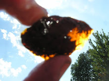
UPDATE: A subsequent visit to the site produced the following oddly shaped lump of bisqued clay about the size of a walnut:
Like the pieces described above, this lump of fired clay has no connection to a piece of completed, fired pottery and contains no quartz temper. What is it and why was it fired to bisque temperature?

References Cited

Bourque, B., S. Cox, R.L. Whitehead. 2001. 12,000 Years: American Indians in Maine. Univ. of Nebraska Press.
Doyle, R.G. 2008. Identification of Lithic Artifacts from Central Maine Coastal Archaeological Sites: A Case Study in Regional Lithic Acquisition Strategies. Flying Passage Press. Gardiner, Maine.
Rhodes, D. 1971. Clay and Glazes for the Potter. 14th printing. Chilton Book Company, New York.