North Twin Mountain is just a few miles to the north of Black Mountain near the Rumford/Andover line in western Maine, south of Maine Route 120.
Swains Notch is a split in the mountain chain, marked by a pond, where Phillip Morrill et al. (1958) described large quartz crystals in the 'dirt.' North and South Twin Mountains are historically documented as having unmined beryl pegmatite deposits on their shoulders.
In 1998 on a very rainy June day I got antsy around the house and drove 50 miles to 'attack' Swains Notch and North Twin Mountains and force them to divulge their secrets. What a mistake.
First, it was pouring out. Intermittently, but still pouring 15 minutes of each hour.
Second, I had not even a good USGS map to direct me; just the old Phillip Morrill quads from the Winthrop Mineral Shop.
Third, I had no idea where I was going, except to the end of 'Swains Notch Road' off the road leading to the Black Mountain quarry.
But what the hey. So I got out, shouldered pack, hammer and went uphill. Uphill seemed a good direction to go.
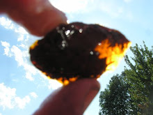
After about an hour of steep climbing, in intermittent yet pouring rain, I did find some unmined, glacially scoured pegmatite outcrops on the southern shoulder of North Twin Mountain. And rough but large beryl crystals were exposed in the pegmatite, if you ripped giant carpets of moss off them and coated yourself in mud. But hey. Edmund Bailey did it at Black Mountain in 1880. But maybe not in the pouring rain.
So I've climbed 1,000 feet, am totally sweaty and totally soaking wet and it is pouring out, did see some in situ beryl but its getting toward 3 or so, not that I have a watch. It just seems 3 or so. Better get off the mountain. Start following logging roads.
But they seem to be heading in endless zigzags. There is no 'down'; just a down followed by an 'up.' Where am I? I have no clue.
On a clear day I could climb a tree and get my bearings from Black Mountain, or any high spot, I know the terrain and landmarks fairly well. But it's pouring and foggy. Visibility is about 300 feet and no sign of it lifting.
I'm totally soaked now, 4 layers of clothes, it's pouring and I'm watching a ruffed grouse who is not so worried as myself. I know from my mental map (no compass ! idiot) that if I walk off the east side of the mountain I will not hit a road for about 5 miles, the Isthmus Road and it will be long past dusk. But I also know that my car is only about 1.5 miles away at most -- if I walk in the right direction toward it. And I have no idea and the logging roads are all doing curlicues and cul de sacs.
But then, in a birch grove, near a brook, a breeze ... a smell ... coming from downhill ... badly cooked cabbage and clam flat gas! Rumford. The smell is my compass!
There was a while I was a bit scared because I had never been so thoroughly lost before. But like a monkey with a typewriter I randomly moved toward the door and downhill and took a correct turn and saw Swains Pond, which I had never seen before, but I knew it was the right way. And the rain started to let up. It was just kind of misty when I popped out of the road at the end of the pond and after another half hour found the car.
It's quite a beautiful place.
Subscribe to:
Post Comments (Atom)


2 comments:
Great stories, this and the rose quartz. Makes me want to go get soaking wet.
supreme
paul george shoes
golden goose
golden goose
goyard outlet
bape hoodie
fear of god clothing
supreme new york
kevin durant shoes
yeezy boost 350 v2
Post a Comment