
Lori Watts and Tim Watts paddle through the "veldt" of the Sebasticook River in Winslow, Maine, three miles above the Kennebec River and two miles below the Benton Falls dam on July 4, 2009. All the low greenery you see has been underwater since 1908, when the Fort Halifax Dam was built at the mouth of the Sebasticook. The Fort Halifax dam was removed in summer 2008, revealing the Sebasticook in its natural condition for the first time in a century.
Atlantic salmon have now confirmed that the Sebasticook River, the largest tributary of Maine's Kennebec River, is an Atlantic salmon river.
Atlantic salmon made this confirmation in late July and early August of 2009 by swimming up to, and into, and through, the mechanical fish elevator at the Benton Falls Dam in Benton, Maine. As of early August 2009, four Atlantic salmon have made this confirmation.
These four Atlantic salmon are the first Atlantic salmon that have swam in the Sebasticook River since 1837, when the Edwards Dam was built (without fish passage) 18 miles downstream on the Kennebec River in Augusta, Maine, and the Fort Halifax dam was built (without fish passage) at the mouth of the Sebasticook River in Winslow, Maine in 1908. 2009 marks the first year since 1837 that Atlantic salmon have been able to swim from the Atlantic Ocean up the Kennebec River and into their native spawning grounds in the Sebasticook River.
And although there are only 30-50 Atlantic salmon left in the entire Kennebec River today (from a population of 100,000 Atlantic salmon before the river was dammed in 1837), these four Atlantic salmon swam into the Sebasticook River as soon as they could swim into it.

The Sebasticook River just below the Benton/Winslow line and Pattee Pond Brook, August 2008. Before the Fort Halifax Dam was removed in July 2008, this entire reach of fastwater was a shallow, stagnant, pond-like impoundment. The tree line and areas of bright green grass show where the impoundment used to be.

Lounging in prime Atlantic salmon juvenile habitat in the Sebasticook River one half mile below Benton Falls, August 2008. These rapids were flooded and still until the Fort Halifax dam was removed in Winslow in July 2008. The Fort Halifax dam eliminated every bit of Atlantic salmon habitat in the 5.5 mile reach of the Sebasticook from the river's mouth to Benton Falls. With the dam's removal, all of this habitat has been restored.
The four Atlantic salmon passed at the Benton Falls dam in summer 2009 are now somewhere in the hundreds of miles of mainstem and tributary reaches of the Sebasticook River. At some place in the river, which they will select themselves, they will mate and give birth in late October. Their eggs, cradled in a bed of glacially smoothed stones dug out by their mother at the tail of a pool, will create next spring the first generation of Atlantic salmon born in the Sebasticook River since Martin Van Buren was president. This will restore a springtime ritual which has occurred on the Sebasticook every spring for the past 12,000 years. Next spring baby Sebasticook River Atlantic salmon the size of a paper clip will wriggle out of the river gravel nests their mother dug for them, see a big, wavy yellow ball in the sky, and begin to eat small insects, and grow, and learn to avoid kingfishers, mink, great blue heron, osprey and otters.
And those baby salmon that survive in the Sebasticook for two years will swim down to the Kennebec and to the Gulf of Maine and then swim 1,500 miles across the Atlantic Ocean to East Greenland to feed on krill and capelin and become Atlantic salmon and then return as adult fish as long as your leg to dig their own nests in the same glacially smoothed stones where they were born. These salmon will be the first generation of Salmo salar var. Sebasticook interruptus. These Atlantic salmon will be giant, vibrant, leaping silver fish no human or snapping turtle or skunk cabbage on the Sebasticook has ever seen in its life, or even in its great great grandmother's life. They will be new but also very old.

A baby Atlantic salmon (called a "fry") just a few days after swimming out of its nest in river gravel. This Atlantic salmon fry was photographed in Mill Brook, Presumpscot River, Westbrook, Maine in May 2005.

When they first swim out of the gravel, baby brook trout and Atlantic salmon look nearly identical and are about the length of a paperclip. This is a baby native brook trout from a spring fed brook in Raynham, Massachusetts. Photo by Tim Watts.
How the Sebasticook River has been restored.
During the past 170 years, the Sebasticook River and its tributaries have been the subject of more human abuse and degradation than almost any river in the United States.

Queequeg T. Dog, Ph.D. does his part to remove a century of human offal from the bed of the Sebasticook River in Winslow, Maine. July 4, 2009.
2,000 years before the Great Pyramid was built at Giza; 4,000 years before Jesus Christ was born; 5,000 years before Leonardo DaVinci drew in his notebook a design for a helicopter; and 8,000 years before dams were built by English-Scots entrepreneurs at Augusta and Winslow, Maine, countless people lived and travelled and laughed and cried and had petty domestic squabbles and put their bratty kids in time out and watched and wondered at Atlantic salmon as they leaped into the air above the pools and runs and rapids of the Sebasticook River.

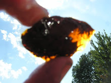
This Native American pot shard was found by Tim Watts along the Sebasticook River below Benton Falls in 2008. It is between 1,000 and 2,800 years old. Judging by the rim curvature, the original pot from which this shard came from was about 12-14 inches in diameter. Note the multiple decorative techniques, including a herringbone design (probably made with a twisted cord or twine) above a series of holes most likely made with a twig, with a more delicate corded impression in between each hole.

Close examination of the surface of this pot shard shows numerous small pieces of quartz embedded in the clay. This quartz is called "temper" and was added to the clay to make it stiffer, stronger and easier to work into large forms. The quartz pieces created small radial cracks in the clay as they expanded during firing. Adding materials to raw clay like quartz or previously fired clay (called "grog") to enhance its workability and strength is still a common practice among potters today, especially when making large vases and vessels.
Native Americans did not use pottery wheels but instead used the coil-built method. To make a pot with coils, the potter rolls out long "snakes" of clay on a flat surface, forms each into a circle, and stacks the coils on top of one another until the desired pot size and shape is achieved. The coils are then pressed and sealed together by hand to make a smooth, uniform surface. Finally, any decoration the potter desires is applied to the smoothed surface, using small wooden tools or cord or twine.
The clay for this pot is most likely local marine clay, which occurs in extensive beds along the Sebasticook and Kennebec river banks. This clay was deposited approx. 15,000 years ago when the entire Kennebec valley was flooded by the Atlantic Ocean as the glaciers melted and sea level rose due to the depression of the Earth's crust from the weight of the one mile thick sheet of ice that had covered Maine for thousands of years. Marine clam, whelk, mussel, scallops and periwinkle shells are sometimes found in the clay beds on the Kennebec. These shells, like the clay they are embedded in, are more than 11,000 years old. Some of the mollusk species found in the Kennebec clay deposits are still found in the Arctic Ocean today (thus showing the type of climate which existed in Maine when they were alive) while some other species are now extinct.

Close-up of a typical Kennebec River valley marine clay bed. The round little saucer is a clay concretion, which seem to have been made by clay particles (which have a slight electrical charge) coalescing round a small particle of stone or shell, much like a pearl in an oyster. This clay bed was uncovered during the construction of the new Hannaford supermarket at the site of the old Cony High School in Augusta.

Here's a small tray I made using the blue marine clay shown in the photo above. I added 20 percent "ball clay" (a very plastic clay from England) to enhance the workability of the Kennebec clay. The face is from the plastic head of a "Ken doll" that I found while digging up the garden.
The banks of the now-restored reach of the Sebasticook River from Winslow to Benton Falls have revealed one of the most dense and intense collections of ancient human artifacts found in North America. In some places along the Sebasticook, nearly every rock along the river bank shows signs of being selected, handled and used by an earlier civilization as a heating utensil to cook food ('fire cracked rock') or as the shard or remnant ('debitage') from a carefully crafted tool. The entire banks of the Sebasticook River from Winslow to Benton should be declared a UNESCO World Heritage Site. It is very difficult to find a place anywhere in the world where you can bend over and pick up any rock and have it be a tool or object that was left in that exact same spot by a human who stood there in 5,000 B.C. The entire bank of the Sebasticook River in Winslow and Benton is like this now.

A typical piece of fire cracked rock from the bank of the Kennebec River at Bacons Rips, Augusta, Maine. Diagnostic features include a baseball shape with a clean, sharp broken surface and a red to orange surface rind from the heating and oxidation of iron impurities in the rock, which in this case is a medium grained, glacially rounded granite cobble.
"Fire cracked rock" (or "FCR" in archaeologist shorthand) is by far the most common prehistoric artifact found in Maine and New England. The origin and use of FCR is quite fascinating. Prehistoric people in New England cooked much of their food as stews or "pottage" in deer or moose skin bags (and later in ceramic pots). To heat and cook the food, they built fires and placed small, round, baseball sized rocks in the flames and coals until the rocks were glowing hot. These rocks were then put into the skin bags and (later) ceramic pots, whereby they released their stored heat into the water and cooked the food. The rocks were used over and over again until finally they split into pieces and were discarded. While not obvious to the layperson, fire cracked rock is easily identified after some practice and the assistance of someone with experience in archaeology. After awhile, the stuff sticks out like a sore thumb. In general, prehistoric people selected smooth, glacially rounded pieces of granite or similar igneous rock the size of a baseball for cooking. These type of stones are the dominant material found on the banks of New England rivers and streams. Because granite has no folding or bedding (unlike metamorphic or sedimentary rocks), it is extremely resistant to cracking and breaking. After being used as FCR, these stones commonly have a distinctive red to orange surface rind (caused by small amounts of iron in the rock oxidizing during heating) and are usually cleanly cracked into halves or thirds due to the stress of repeated heating and being dunked into water when they are red hot.

A partly completed arrow head made of transparent jasper, found on the Sebasticook River in Winslow by Ricky Churchill of Plymouth, Mass. in August 2008. This type of jasper is not found in Maine and illustrates the extensive trade networks that existed between Maine, Canada and the southern Atlantic seaboard millennia ago.
Historian and Penobscot language expert Fannie Hardy Eckstorm of Brewer, Maine provides the following information in her exploration of the origins of the word Sebasticook, or as she spells it, Sebesteguk:
"To appreciate why the Sebesteguk was of such importance in Indian communications we should note the topography of its drainage basin. The Sebesteguk fans out in wide spreading branches. The longer but lesser branch, rising in Sangerville and Dover, was known as Main Stream; the shorter and more important branch, with its chief head in Newport, was called the East Branch. Probably originally only the main river and its East Branch were known as Sebesteguk, "the almost-through river," because this was the shortest and easiest route to the Penobscot. The Reverend Paul Coffin, in his Missionary Journeys in Maine at the end of the 18th century, noted that it was but a mile overland from Penobscot to Kennebec waters by the Sebesteguk and Sawadapskek ... Thus the Sebesteguk was a main highway of aboriginal travel ..."
During the many thousands of years when canoe travel was the preferred (and only sensible) method of inland travel in Maine, the Sebasticook was the way to travel from east-west from the Kennebec and Penobscot watersheds. This is easily seen on any map, which shows the headwaters of the Sebasticook linked by a carry of a mile or less from the headwaters of the Souadabscook, a principal tributary of the lower Penobscot River, to the Penobscot. Prior to the construction of roads in the early 1800s, the Sebasticook River was the only way, short of a dangerous and long coastal sea voyage or a nasty, convoluted, mosquito infested swamp trek, to travel east or west between Maine's two largest river drainages.
IMPORTANT NOTE: It is unwise, unethical and (in many cases) illegal to dig in or disturb archaeological sites. The artifacts shown above from the Sebasticook River are all "surface finds" -- they were simply lying on the river bank. It is critically important that if you choose to pick up and bring home surface finds like the one above that you contact your state's historic preservation commission or local university's archaeology department, describe your finds and exactly where you found them, and offer them the opportunity to view and photograph them (and if possible, take high quality photos and email them to the state archaeologist). In most cases, the archaeologist is already familiar with the area and the type of surface finds you have encountered. However, it is always possible that you might have stumbled upon a locality that is unknown to archaeologists and/or the artifacts you have found are unique or unusual and are of scientific interest. This is why it is important that you get acquainted with your local archaeological agency if you choose to bring anything home. To do otherwise, you become a "pot hunter," which is a derisive archaeological term for someone who deliberately loots and destroys archaeological sites without any regard for the scientific and cultural value of the artifacts they are taking and the damage they are causing. And lastly, surface artifact collecting on American Indian lands and state and national parks is strictly forbidden in nearly all cases and can result in hefty fines or jail time. Don't be a pot hunter. And never dig into a site where you make a surface find. You may be destroying priceless and irreplaceable information.


